

INDIANAPOLIS — Severe storms – and possibly tornadoes – are making their way toward central Indiana on Tuesday, May 7.
A tornado watch has been issued for most of central Indiana until 9 p.m. The biggest threats include heavy rain and hail.
Click here to track the storms through Live Doppler 13 Radar.

Scroll down for the latest updates on the storms.
Severe weather updates:
May 8, 2024
Damage surveys by the National Weather Service found 5 separate tornadoes touched down on Tuesday in Indiana.
One of those was in Shelby County, three were in Rush County and one was in Decatur County.
May 7, 2024
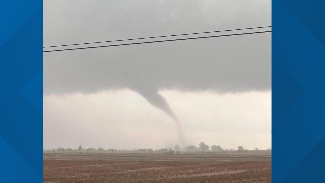
11:59 p.m. - We just received this photo from Bradley Davis, which he took Tuesday southeast of Orange Pike, Rushville.

11:40 p.m. - A Tornado Watch for Bartholomew, Brown, Lawrence and Monroe counties is in effect until 2 a.m.
11:35 p.m. - A Tornado Warning for Lawrence County is in effect until 11:45 p.m.
11:17 p.m. - A Severe Thunderstorm Warning for Bartholomew & Brown counties is in effect until 12
11:11 p.m. - A Tornado Warning is in effect for parts of Monroe, Martin, Lawrence and Greene counties until 11:45 p.m.
10:45 p.m. - A Tornado Watch for Decatur, Fayette and Rush counties is in effect until 1 a.m.
10:35 p.m. - A Severe Thunderstorm Warning for Monroe and Owen counties is in effect until 11:15 p.m.
10:25 p.m. - Viewers reported seeing a tornado in Rush County.
8:40 p.m. - A Tornado Watch for Decatur, Fayette, Rush and Wayne counties is in effect until 1 a.m. Wednesday.
8:30 p.m. - A Flash Flood Warning for Fayette County is in effect until 12:30 a.m. Wednesday.
8:29 p.m. - A Severe Thunderstorm Warning for Bartholomew, Decatur, Rush and Shelby counties is in effect until 9:30 p.m.
8:27 p.m. - Tornado Warning for northwestern Franklin County in southeastern Indiana, southwestern Union County in east central Indiana and southern Fayette County in east central Indiana until 9 p.m.
8:20 p.m. - A Severe Thunderstorm Warning for Bartholomew, Brown, Johnson, Monroe and Morgan counties is in effect until 9 p.m.
8:05 p.m. - A Severe Thunderstorm Warning for Randolph County is in effect until 8:30 p.m.
8:02 p.m. - Tornado Warning issued for southeastern Shelby County, southern Rush County and northern Decatur County until 8:30 p.m.
At 8 p.m., a severe thunderstorm capable of producing a tornado was located 9 miles southeast of Shelbyville, moving east at 40 mph.
8 p.m. - A Severe Thunderstorm Warning for Decatur, Rush and Shelby counties is in effect until 8:45 p.m.
7:58 p.m. - A Tornado Warning is in effect for southeastern Rush County until 8:15 p.m.
7:50 p.m. - A Severe Thunderstorm Warning for Johnson and Shelby counties is in effect until 8:30 p.m.
A Severe Thunderstorm Warning for Fayette a Wayne counties is in effect until 8:15 p.m.
7:35 p.m. - A Severe Thunderstorm Warning for Rush and Shelby counties is in effect until 8:15 p.m.
7:20 p.m. - A Severe Thunderstorm Warning for Johnson County is in effect until 8 p.m.
6:45 p.m. - A Severe Thunderstorm Warning is in effect for Owen County until 7 p.m., Johnson County until 7:15 p.m., and Morgan and Putnam counties Severe Thunderstorm Warning is in effect until 7:30 p.m.
6:35 p.m. - A Tornado Warning for southeastern Grant County and Blackford County is in effect until 7 p.m.
6:34 p.m. - A Severe Thunderstorm Warning for Johnson and Morgan counties is in effect until 7:15 p.m.
6:30 p.m. - A severe thunderstorm warning for Owen County is in effect until 7 p.m.
6:20 p.m. - A tornado warning has been issued for southern Grant County until 6:45 p.m.
6:05 p.m. - A severe thunderstorm warning for Miami County is in effect until 6:30 p.m.
6:05 p.m. - A severe thunderstorm warning for Grant County is in effect until 6:30 p.m.
6 p.m. - A tornado watch for Decatur, Delaware, Henry, Randolph and Rush counties is in effect until 1 a.m.
5:48 p.m. - A tornado warning for southeastern Howard County and northern Tipton County is in effect until 6:30 p.m.
At 5:45 p.m., a severe thunderstorm capable of producing a tornado was located 11 miles east of Frankfort, moving east at 35 mph.
5:45 p.m. - A severe thunderstorm warning for Hendricks, Morgan and Putnam counties is in effect until 6:15 p.m.
5:30 p.m. - A severe thunderstorm warning for Clinton, Howard and Tipton counties is in effect until 6:30 p.m.
5:15 p.m. - A severe thunderstorm warning for Putnam County is in effect until 6 p.m.
4:30 p.m. - A tornado warning has been issued in Terre Haute in Vigo County and Brazil in Clay County until 5:15 p.m.
4:30 p.m. - A tornado watch is in effect through 9 p.m. for Bartholomew, Benton, Boone, Brown, Carroll, Cass, Clinton, Fountain, Grant, Hamilton, Hancock, Hendricks, Howard, Johnson, Lawrence, Madison, Marion, Miami, Monroe, Montgomery, Morgan, Owen, Putnam, Shelby, Tippecanoe, Tipton, Warren and White counties.