INDIANAPOLIS — It was a devastating night for many in the Midwest as severe storms and an outbreak of tornados swept through multiple states including Indiana. There were many storm reports, including tornadoes, damaging wind and large hail.
There were over 30 tornadoes reported. One of the deadliest his in Mayfield, Kentucky.
“I pray that there will be another rescue. I pray that there will be another one or two,” Kentucky Gov. Andy Beshear said, as crews sifted through the wreckage of the candle factory in Mayfield, where 110 people were working overnight Friday when the storm hit.
In Kentucky alone, 22 were confirmed dead by Saturday afternoon. But Beshear said upwards of 70 may have been killed when a twister touched down for more than 200 miles (320 kilometers) in his state and that the number of deaths could eventually exceed 100 across 10 or more counties.
The death toll of 36 across five states includes six people in Illinois, where an Amazon facility was hit; four in Tennessee; two in Arkansas, where a nursing home was destroyed; and two in Missouri.
Central Indiana had many wind reports. There were a couple of Tornado Warnings issued for central Indiana, but thankfully there weren't any tornado reports.
Live updates on severe weather across Indiana Friday night into Saturday:
8:56 p.m. - The National Weather Service in Chicago confirmed that there was tornado damage in Cedar Lake, Indiana, which is in Lake County. It was an EF0 tornado with peak winds of 85 mph.
This is the first December tornado for Lake County, Indiana since recording began in 1950.
4:15 p.m. - Indiana Task Force 1 leaves for Kentucky. A group of 45 will help with search and rescue operations in Mayfield, Kentucky.
12:15 p.m. - Power crews continue to deal with downed poles and lines due to high winds.
Duke Energy reported more than 17,000 customers without power early Saturday afternoon. The utility posted an update on its website asking for patience as crews deal with high winds while attempting to make repairs.
Hardest hit communities in Duke's service area include Kokomo, McCordsville and Bloomington, where at least 3,000 customers each are without power.
More than 12,500 AES customers in and around metro Indianapolis are reporting outages - more than double the number from just four hours ago.
Activities scheduled Saturday at New Palestine's Winterfest have been postponed until Friday, Dec. 17 due to the high winds.
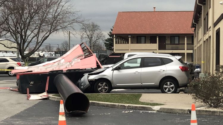
10:22 a.m. - Carmel Fire crews helped clear a tree that fell on a house and landed just above the crib where a child was sleeping. Luckily, no one was injured.
9:18 a.m. - First responders say a 3-year-old child was not injured when overnight storms caused a large tree to fall on her home sending debris in her crib. The girl's father quickly rescued the child and she was transported to Riley Hospital for Children as a precaution.
8 a.m. - AES is reporting 6073 customers without power in Marion County.
Duke Energy reported just under 9,000 customers statewide without power. Nearly 3,000 were in Monroe County and more than 1,000 were in Boone County. Power has been restored to most of the 3,400 customers who were without power in Johnson County earlier this morning.
South Central Indiana REMC shows another 1,300 of its Monroe County customers out of power. Almost 2,000 customers in Brown County are in the dark.
5:30 a.m. - AES reports 6943 customers without power in Marion County.
Duke Energy shows 12,440 customers out statewide, with more than 3,400 of those in Johnson County.
Indiana Michigan Power shows more than 4,000 Indiana customers in the dark including some in Delaware County.
5:00 a.m. - Rain has cleared the state.
3:50 a.m. - A severe thunderstorm warning is in effect for Wayne, Fayette and Union counties until 4:30 a.m. Saturday.
3:22 a.m. - Authorities in Clinton County report minor storm damage there.
Emergency Management Agency Director Mike Fincher said some trees and power lines were down on roadways. He said he had received no reports of damage to homes or businesses.
3:10 a.m. - Shortly after 3 a.m. Saturday, AES Indiana reported 10,800 customers without power, while Duke Energy was reporting 291 outages impacting nearly 15,000 customers statewide.
3:04 a.m. - A severe thunderstorm warning is in effect until 3:30 a.m. for Monroe, Shelby, Morgan, Johnson, Brown and Bartholomew counties. There are also reports of pea-sized hail near the Indiana University campus.
2:39 a.m. - A severe thunderstorm warning was issued for Delaware, Madison and Henry counties until 3 a.m.
Meanwhile, the severe threat continues to diminish for the western part of the area, including Marion County.
2:25 a.m. - A severe thunderstorm warning has been issued for the far northern part of Marion County and part of Hamilton County until 2:45 a.m.
2:17 a.m. - The severe threat is diminishing for several counties in Indiana as storms move to the east.
2:05 a.m. - Duke Energy is now reporting nearly 12,000 customers without power at 2 a.m. Saturday. AES Indiana reports just over 4,000 customers in Indianapolis experiencing a power outage.
1:20 a.m. - Another severe thunderstorm warning has been issued until 2:15 a.m. for Hamilton, Tipton, Madison and Delaware counties, including Muncie, Anderson and Yorktown.
1:05 a.m. - A severe thunderstorm warning has been issued until 1:30 a.m. for several counties in north central Indiana.
The warning box includes portions of Putnam, Montgomery, Hendricks, Boone, Hamilton, Tipton, Madison and Howard counties. Cities affected by the warning include Crawfordsville, Ladoga, Lebanon, Thorntown, Sheridan, Cicero, Tipton and Elwood.
12:52 a.m. - Thousands of people are without power as storms rumble through central Indiana.
Just before 1 a.m., about 3,800 Duke Energy customers statewide were experiencing a power outage. In Indianapolis, 2,000 AES Indiana customers were without power, mostly due to two outage incidents - one near Rocky Ripple on the north side and another at West 86th Street and North Michigan Road on the northwest side.
12:23 a.m. - A tornado watch has been issued for most of the eastern half of Indiana until 6 a.m. Counties in the western half of the state remain under a tornado watch until 3 a.m.
12:15 a.m. - Radar shows a possible tornado debris signature in Eugene, Indiana in the western part of the state, Sean Ash reports.
12 a.m. Saturday - Angela Buchman and Sean Ash are live on the WTHR Facebook page with a live update on the severe weather.
11:51 p.m. - A tornado warning is in effect until 12:15 a.m. for Fountain, Parke and Vermillion counties in western Indiana.
11:36 p.m. - Two people were killed and at least five were injured when a tornado struck a nursing home in Arkansas Friday night.
Craighead County Judge told KAIT-TV in Jonesboro, Ark., that at least 20 people were trapped after the tornado struck the Monette Manor area.
11:05 p.m. - Emergency crews have responded to an Amazon warehouse in Edwardsville, Illinois, east of St. Louis, where a roof was torn off by Friday's storms and part of the building collapsed.
11:00 p.m. - Angela Buchman has a storm update.
10:50 p.m. - While the severe storms have passed around Indianapolis so far Friday night, the supercell that has been moving northeast from Arkansas and Tennessee is approaching Benton, Kentucky, about 110 miles southwest of Evansville, Indiana.
10:02 p.m. - Angela Buchman is live on the WTHR Facebook page with the latest on tonight's severe weather.
Angela points out that even though the tornado watch that was issued only covers the western counties, a possibility of severe weather should not be ruled out for counties to the north and east of the watch area. That includes Hamilton, Hancock, Madison and Shelby counties in the metro area.
9:43 p.m. - A Severe Thunderstorm Warning has been issued for counties to the south and east of Indianapolis including the cities of Nashville, Edinburgh and Shelbyville.
9:30 p.m. - Angela Buchman has an update on the severe weather as it moves east. Join her live on the WTHR Facebook page shortly after 10 p.m. and throughout the evening as conditions warrant.
9:00 p.m. - A tornado watch is in effect until 3 a.m. for most of the western half of Indiana, including Indianapolis.
Severe storms are expected to move in late Friday night through the overnight hours.
Counties in the current watch area include Bartholomew, Boone, Brown, Clinton, Greene, Hendricks, Jackson, Jennings, Johnson, Lawrence, Marion, Monroe, Montgomery, Morgan, Owen, Putnam and Tippecanoe.
STAY WEATHER AWARE: View interactive radar
Stay weather aware overnight and make sure you have a way to be notified of severe weather in your area, even while you sleep. Make sure you have the Live Doppler 13 Radar app on your phone and make sure your phone is set up to get warnings.
Download the app: App Store | Google Play
You also want to make sure your ringer is turned up and you have the emergency alerts switched on. Don't silence or set your phone to do not disturb mode. With such a rare event in December and late at night, it’s best to stay weather aware.
The 13Weather team will keep you updated as severe weather approaches, both on-air and online. Follow our weather team on social media:
Sean Ash: Facebook | Twitter
Angela Buchman: Facebook | Twitter
Kelly Greene: Facebook | Twitter
Chuck Lofton: Facebook | Twitter
Lindsey Monroe: Facebook | Twitter
Angela Buchman will have the latest on the severe weather tonight at 11:00 on 13News and on the WTHR Facebook page as events warrant.
(NOTE: The forecast below is from Friday, Dec. 10, 2021 at 6 p.m.)