
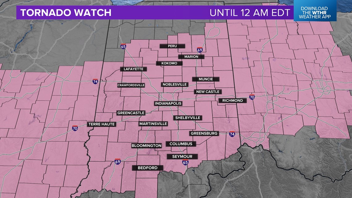
INDIANA, USA — UPDATE: A tornado watch extends from Texas to Ohio, including all of central Indiana. That means at any time, a storm that fires up will have a chance to spin and create a tornado. The tornado watch will expire at midnight.
Tap HERE for our live interactive radar.
Multiple rounds of storms will fire up and push east throughout the evening and tonight as a warm front stalls out over Indiana. This will become a breeding ground for thunderstorms to spark and turn strong or severe. A cold front will clean us out before sunrise Friday. Until then, storms are possible. Stay weather aware.
Below, we will cover who has the highest chance for hail, wind and tornadoes, plus the timing of the rounds of storms throughout the day.
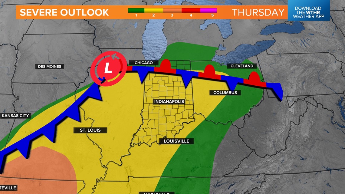
What is the severe setup for the day? (Level 2 out of 5 today)
The boundary you see going east/west to the right of the low pressure is called a stationary front. It was a warm front but has stopped. This will allow the worst storms to fire near this boundary and about 100 miles to the south. Central Indiana has a decent risk for severe weather today.
The cold front farther west will clear us out after midnight, removing our severe threat. The strongest storms today are likely to be to our south in Missouri and Arkansas. However most of Indiana is under a Level 2 severe threat.

What is my risk for hail today?
Hail will be possible in many of the storms today as updrafts are able to rotate and lean, helping hail stones to tap into cooler, drier air in order to get larger. The worst hail storms will likely be near and just south of the stalled out warm front. Orange areas, including most of central Indiana, may be able to see hen egg-sized hail, or roughly 2 inches in diameter.


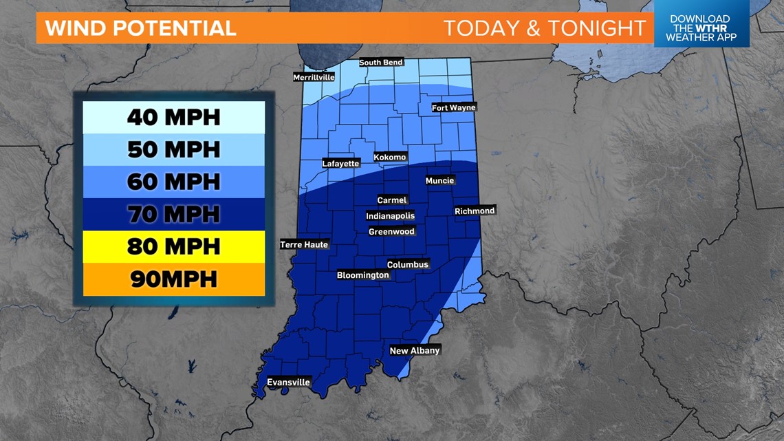
What is my risk for damaging winds?
Any storm that fires will be able to produce winds, but there may be some higher chances for higher winds south of Kokomo. Central and southern Indiana have the highest risk for winds. Especially later tonight, watch as storms start merging and gusting out some 60-70 mph winds in spots.

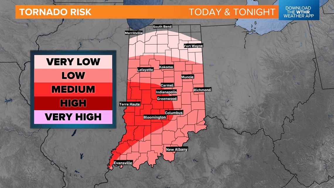
Will I get a tornado today?
The highest risks for Indiana today will be hail and wind, but an isolated tornado is possible as storms rotate near and south of the stalled front. Storms will also have more space in between west of Indianapolis, giving them some breathing room. The tornado risk will be slightly higher for west-central Indiana. Once storms reach southern and eastern Indiana, storms may start getting jumbled up and rain out, which will help lower the tornado chance, but it will not be completely gone.

Who is included in the tornado watch?
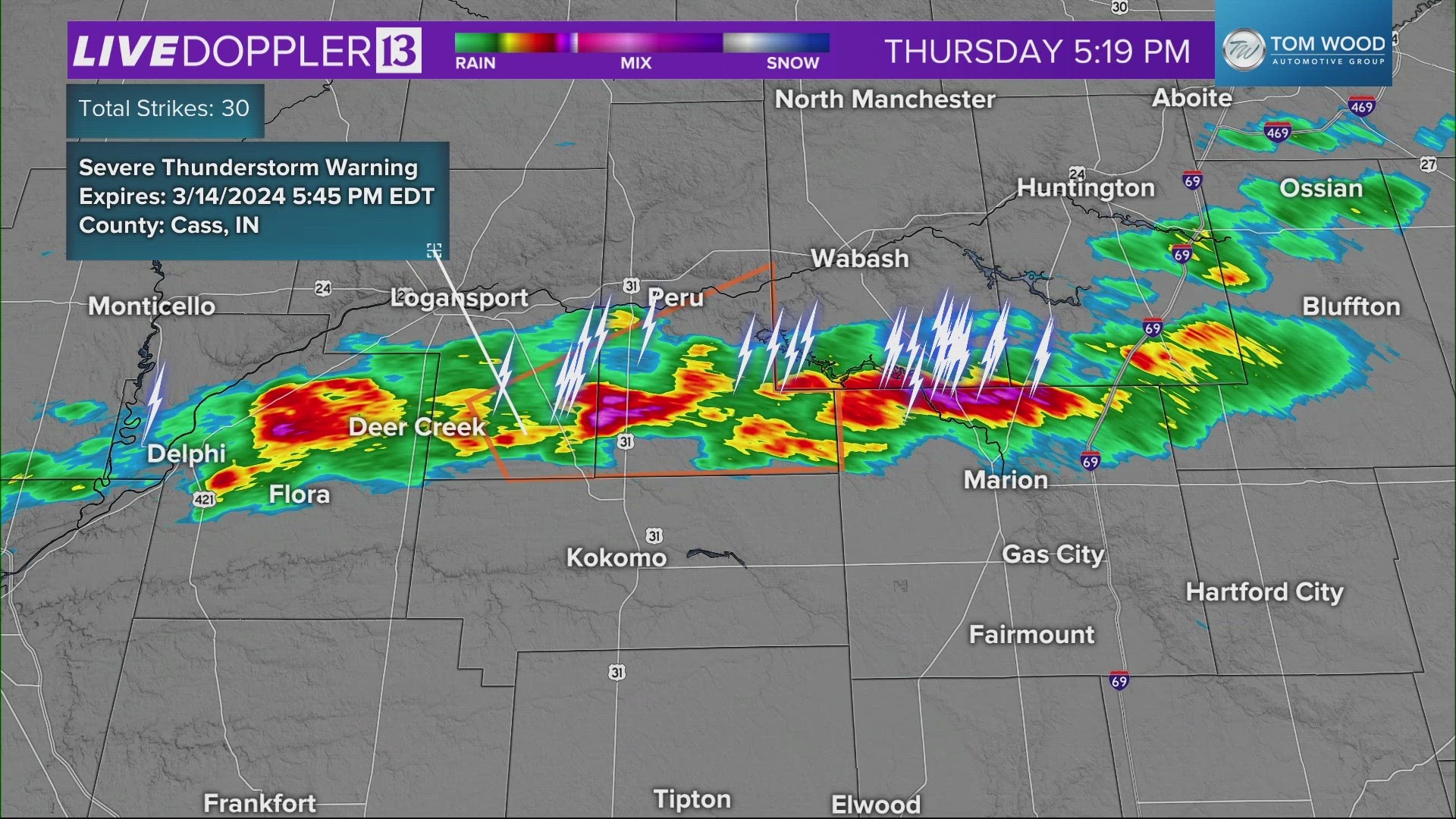
This map will be updated throughout the day, but any county in pink is included in the tornado watch. That means any storm that fires up will have the ability to rotate and possibly create a tornado. All of central Indiana is included until midnight.
Generally watch for the worst storms to be north of Indianapolis until 9PM. From 9PM to midnight, the tornadic threat will gradually move south of Indianapolis. Not every storm may follow this rule, but this should be the general pattern.

When will it storm?
There will be 2-3 rounds of scattered storms today across Indiana, so everyone will get something different. Let's break it down into those rounds:
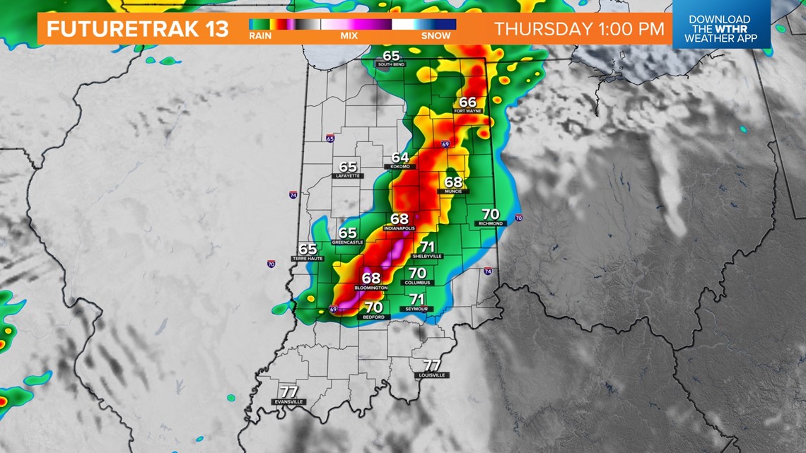
- Round 1 (11 a.m.-3 p.m.) -- COMPLETE
A line of storms will sweep across Indiana from west to east during the middle of the day. The main threat will be gusty winds. Indianapolis will likely get some storms near noon or 1 p.m.

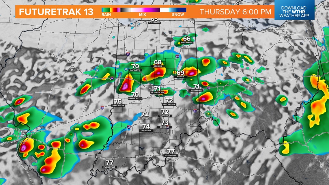
- Round 2 (5 p.m.-10 p.m.) -- central Indiana (scattered strong storms)
After that first line pushes through, the atmosphere will try to recover with more heat and humidity. If it sufficiently can, scattered individual storms will fire up. These can rotate on their own easily. Expect these to be hit-or-miss. Not everyone will get one of these storms, but if you do, they could be nasty at times.

- Round 3 (10 p.m.-3 a.m.) — southern Indiana (scattered storms and widespread rain)
Cooler air will start to push rain and thunderstorm chances farther south. Some of these will still be severe, but they may start become wind and rain dominant.


Cooler, drier weather will move in for the rest of the week and the weekend. In fact, there will be a light snow chance next week. This warm spell will be over soon for awhile.