

INDIANA, USA — UPDATE: Thunderstorms are wrapping up across southeastern Indiana. The tornado threat is over for Indianapolis.
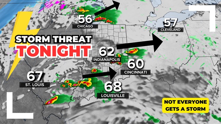
A strong cold front is on the move and is sparking strong storms across the state with tornado, wind and hail threats, but not everyone may get rain. Different parts of Indiana may see various storm types and timings. Let's take a look across the state.
Tap HERE for our live interactive radar to track the storms as they fire up nearby.
(Specific tornado, wind and hail threat maps, plus their timing, are below.)
Temperatures in Indiana will drop 40-50 degrees from Tuesday afternoon into Wednesday morning. The surface front is intense. However to get storms it's not just about the surface. You have to look higher up to see if storms can spark.
What is the atmosphere looking like tonight?
There are different layer of the atmosphere that come into play. This is how they look.
- Upper levels: Getting colder and drier — helps storms thrive
- Mid levels: Pocket of very warm air leftover from yesterday — hurting storm potential
- Ground level: Big cold front with adequate warmth and humidity
The middle layers of the atmosphere will determine who gets storms and who does not. Right now, the middle layer is a little more storm-supportive toward Chicago and then another pocket in southern Indiana. These are the two regions that may get the worst storms on a widescale.

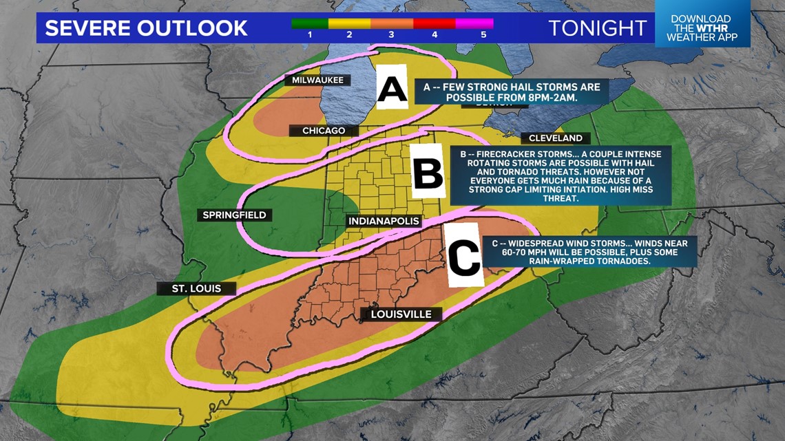
In the map, we have zones A, B and C. Below the zones, we also have the threat map from the Storm Prediction Center. We decided to divide this up a bit:
- Zone A: A few strong hail storms are possible in NW Indiana, thanks to much colder air upstairs by Lake Michigan. The time window to watch for hail stones will be 8 p.m. to 2 a.m.
- Zone B: This is the hardest zone to forecast. The upstairs in the atmosphere looks really supportive for hail storms and some tornadoes. However, there is a warm pocket a few thousand feet up that is trying to diminish storm threats. If something can fire up in this area, it could turn nasty very quickly. There is also a high chance that not a lot develops across central Indiana. Look out from 8 p.m. to 2 a.m. for a couple strong storms. Then, from 2 a.m. to 5 a.m., watch for scattered rain and thunder.
- Zone C: This is the zone we are most confident in for severe weather. This includes most of the southern half of Indiana. Widespread wind storms are possible with some rain-wrapped tornadoes along the leading edge. This area may get multiple rounds of severe storms.


There may be locations across Indiana that don't get much rain at all.
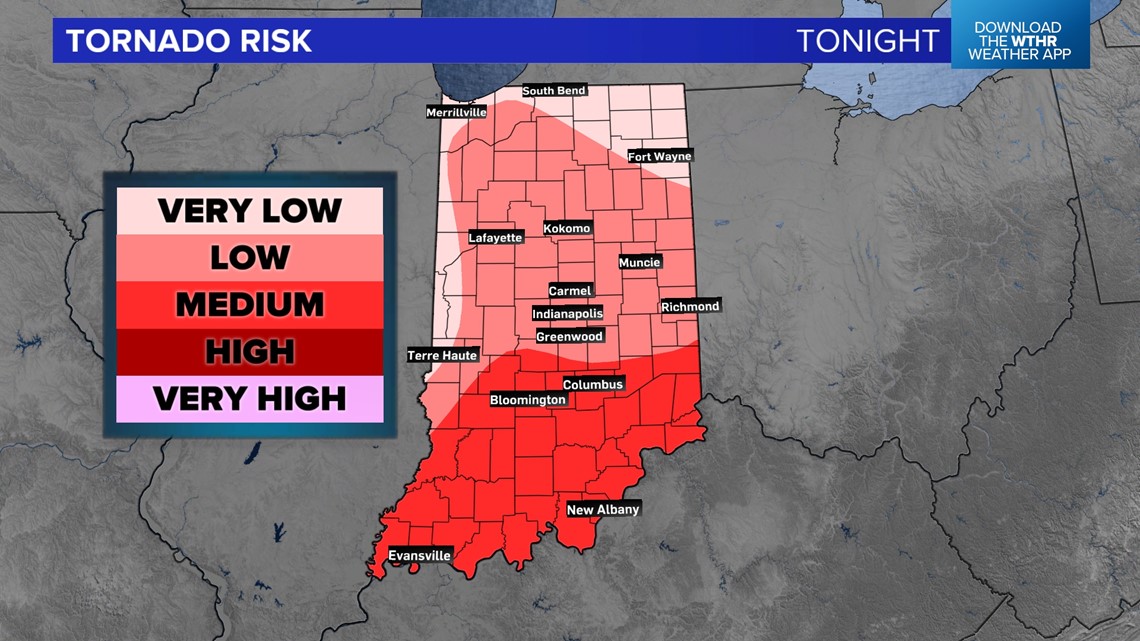
Who has the highest chance for a tornado?
The tornado risk increases in southern Indiana, mainly south of Franklin and Martinsville. There will be more widespread storms near the Ohio River. There could be an isolated storm or two in central Indiana. If these can pop, they would most likely rotate. There is still a chance than central Indiana, including Indianapolis, only get some isolated rain if the storms cannot fire through the cap.

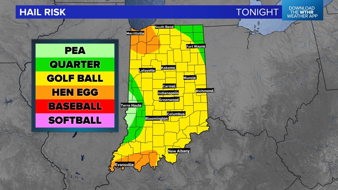
Who has the highest threat for hail?
The highest hail risk is in NW Indiana around Gary, Merrillville, Valparaiso and Crown Point. The air will be colder there upstairs, helping hail stones freeze. Much of the state has the threat for quarter to golf ball-sized hail.

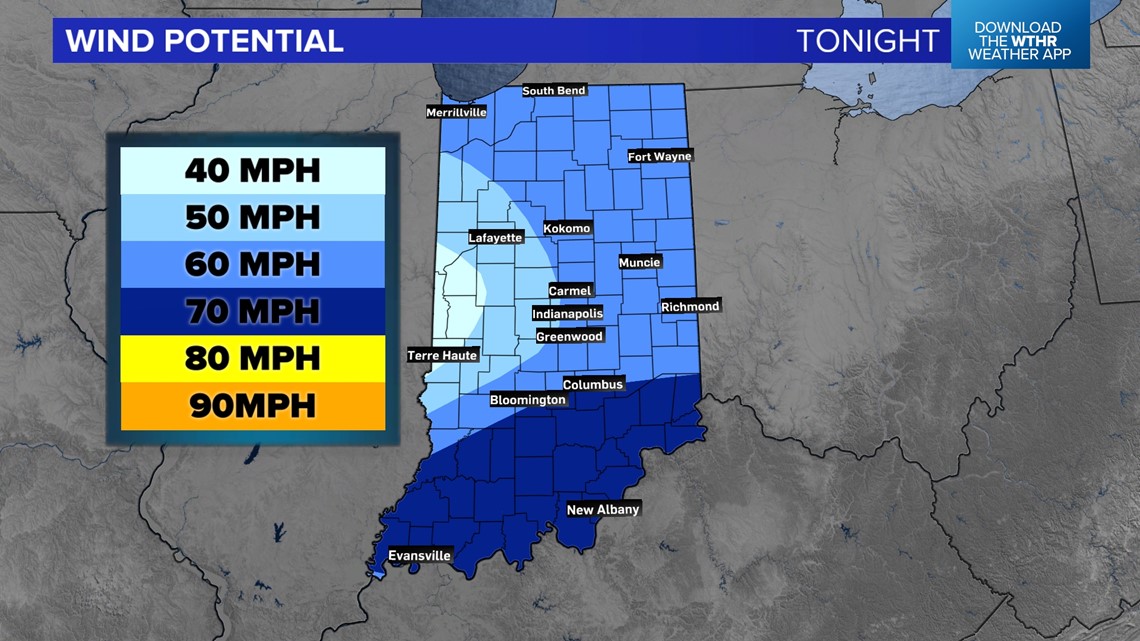
Who may get the worst wind?
Any storm that fires will have the potential for 50-60 mph winds as strong jet stream wind streams may try to duck down toward the ground. However, the highest chance for the worst winds may be in southern Indiana. Gusts could be near 70 mph at times for some of the storms.

Will it snow after the storms?
As northwest winds move in, temperatures will drop into the upper 20s and low 30s Wednesday morning. There may be some lingering low clouds after the front. Watch for some scattered snow flurries across Indiana. Chances for accumulation are low, and the timing for snow will only be from 7 a.m. to 11 a.m.


For folks in northern Indiana in the lake-effect snow belts, the best chance for lake-effect snow showers will stay in Michigan, although a few may skirt the Indiana-Michigan state line.
Is it going to storm where I live and when?
That's the big question: Everyone has a chance for a storm tonight, but not everyone will get one. Northern Indiana and southern Indiana have the highest chance of a storm. Central Indiana may get dodged by the majority of storms, however if one can pop up near Terre Haute, Lafayette, or Indianapolis, it could turn nasty very quickly. There will also be the chance for some in central Indiana to not get much rain at all, too.
Our weather team will have updates all night long to see where the storms are firing and where they are not. Be storm ready from 8 p.m. through 4 a.m. Once the front hits you as temperatures drop below 55 degrees, you should be good!
