

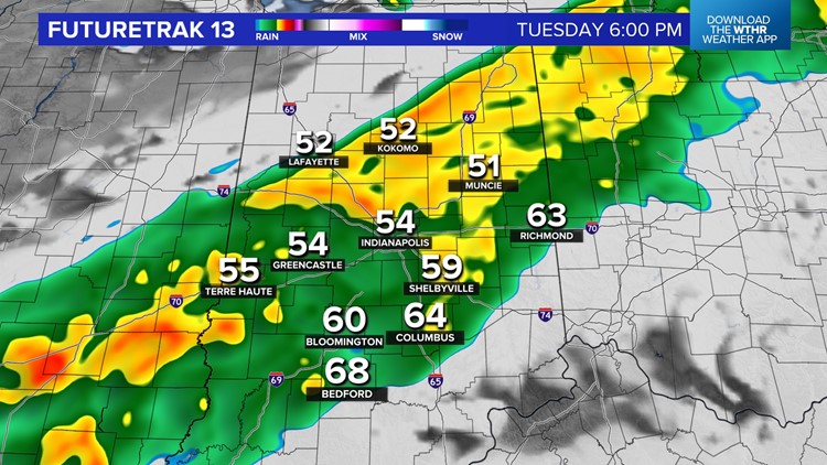
INDIANAPOLIS — It's been an interesting weather day in central Indiana, with our viewing area experiencing two drastically different types of weather. To the north, rainy and much chillier (mainly 40s) within a steadier, heavier rain axis.
This is contrasted by clouds and much milder (60s) for areas along/south of I-70. But the shelf-life on dry weather expires between now and 6 p.m. around the Indy metro area, with a wet commute expected after 4 p.m. And when the rain reaches your area, expect temperatures to drop quickly by some 10° or more.


While thunder shouldn't be rather isolated within this rain band, rain rates may be moderate to locally heavy at times. But rain amounts for most areas south of north-central Indiana likely will be near/below a quarter-inch. Farther north, where it's been raining much longer, half-inch totals will be more likely. However, we're not expecting this will cause any flooding, and rain quickly ends from north-to-south this evening between 7 p.m. and 10 p.m.


You should plan on getting wet if you have outdoor events this evening before 9 p.m. before the front settles to our south. This opens up the gates to a quick jab of cooler air for mid-week that keeps highs in the 50s area-wide Wednesday and possibly some patchy frost Thursday morning when lows drop back into the 30s.


Low cloud cover will range from partial to mostly cloudy on Wednesday, with more overcast the farther north-northeast you live of Indy. The sky will be brighter farther to the southwest. Low clouds clear for mainly sunny conditions on Thursday.
We're back to clouds, a stiffening breeze and expanding rainshield on Friday. This will be on the leading edge of much warmer air coming for the weekend when highs reach the 80s.


