

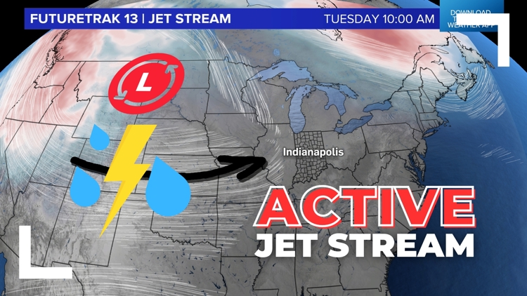
INDIANA, USA — The first full week of May 6-10 looks active across Indiana, with multiple rounds of rain and storms, some of them severe. The jet stream will park in the Corn Belt and Midwest, helping to sling many waves of downpours toward Indiana. The best chances for severe weather may be Tuesday midday and Wednesday night.
Tap HERE to track incoming rain and storms from the west with our interactive radar.
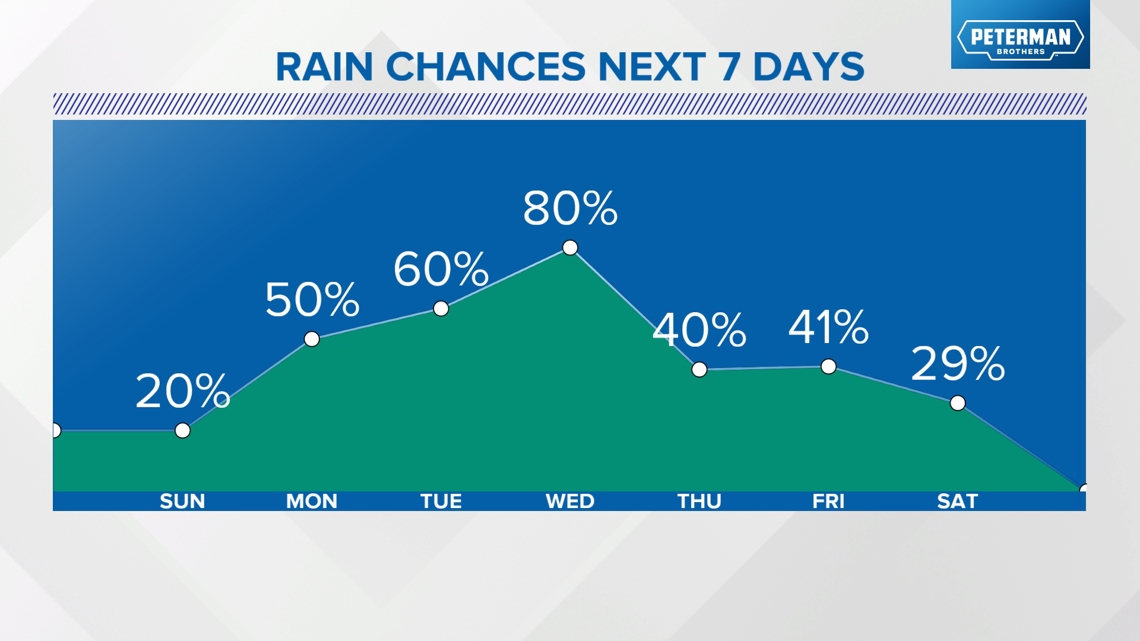
It will not rain constantly throughout the week. In fact there may be some decent sunshine at times. It's that sun and warmth that will help build energy for more storms to come. Let's go day-by-day. Expect changes to this forecast. We will stay fairly vague. It is too early for very specific timing.
For the latest WTHR forecast, tap HERE.

Monday
Monday looks showery at times. Less than a tenth of an inch of rain is probable. Watch for some light rain showers to arrive in the morning from south to north. Some of the showers will linger into the middle of the afternoon. A stray downpour is possible the farther south you go.


By the afternoon, the rain zones will lift north and east, but the majority of the rain should wrap up by 4-6 p.m. Severe weather chances are extremely low for Indiana.

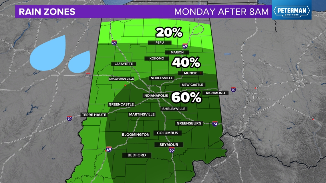
Areas north of Indianapolis will expect even less rain.
Tuesday
By Tuesday the jet will start to approach. This will help funnel moisture and instability for rain and storm develop for the next several days, at least on-and-off.
The early morning should be dry, but later into the morning and early afternoon, watch for more rain and scattered storms Timing is still a bit tough on this one. We're watching to see how quick it comes in. If it arrives closer to 9-10 a.m. then expect weaker storms. If the round of rain and the front hit later in the day, the severe chances will go up. There is an early severe zone from the Storm Prediction Center over Indiana.

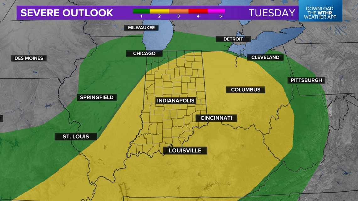
Notice how the zones get higher as you press east into Indiana because storms may press too quickly across Illinois before they can really get going.
After the round of rain and storms hits midday, an isolated downpour is possible later in the day in between rays of sunshine.


Wednesday
We may start the day with some scattered showers, especially if the storms the night before linger for a while across Indiana. In the middle of the day, we should get some sun, helping the atmosphere to warm back up. There may be some hours of really nice weather!
Later in the afternoon, evening and overnight hours, more scattered storms are likely to develop. These may also turn severe. Depending on how much we recover, storm threats may shift a bit farther south.


Thursday and Friday
By Thursday the jet stream should push east, allowing some cooler air to move in. However we may remain unsettled for a few days with scattered showers and some downpours. Some of the rain may be enhanced by Lake Michigan.
This showery weather will be most likely during the middle of the day as we warm temperatures up. Warmer air allows more instability to create these scattered showers.
Friday may be mostly dry if the we can pull the remaining moisture out fast enough.
What to expect overall
Timing will likely change over time, but the general premise remains. Watch for on-and-off scattered rain and storms. Severe threats are possible with wind, hail, and tornadoes, especially Tuesday and Wednesday. In between rain chances, you may get some nice weather. Bits of sun and warmer air will nestle in between the storms.
We may pick up 1-3 inches of rain by next weekend, depending on where the heaviest cells track.
— 13News Meteorologist Matt Standridge.
