
INDIANA, USA — Storm arrival will likely be an hour or two later than initially expected.
Just one more round of wind storms, and then, Indiana is done for the week. Expect a line of strong-to-severe storms to move into Indiana after 8 p.m., with a most active window of thunderstorm chances between 9 p.m. and midnight.
Not everyone will get a nasty storm, but most of us will get some rain, thunder and some wind, especially south of Indianapolis.
Tap HERE to view our interactive radar to track the storms as they move in.
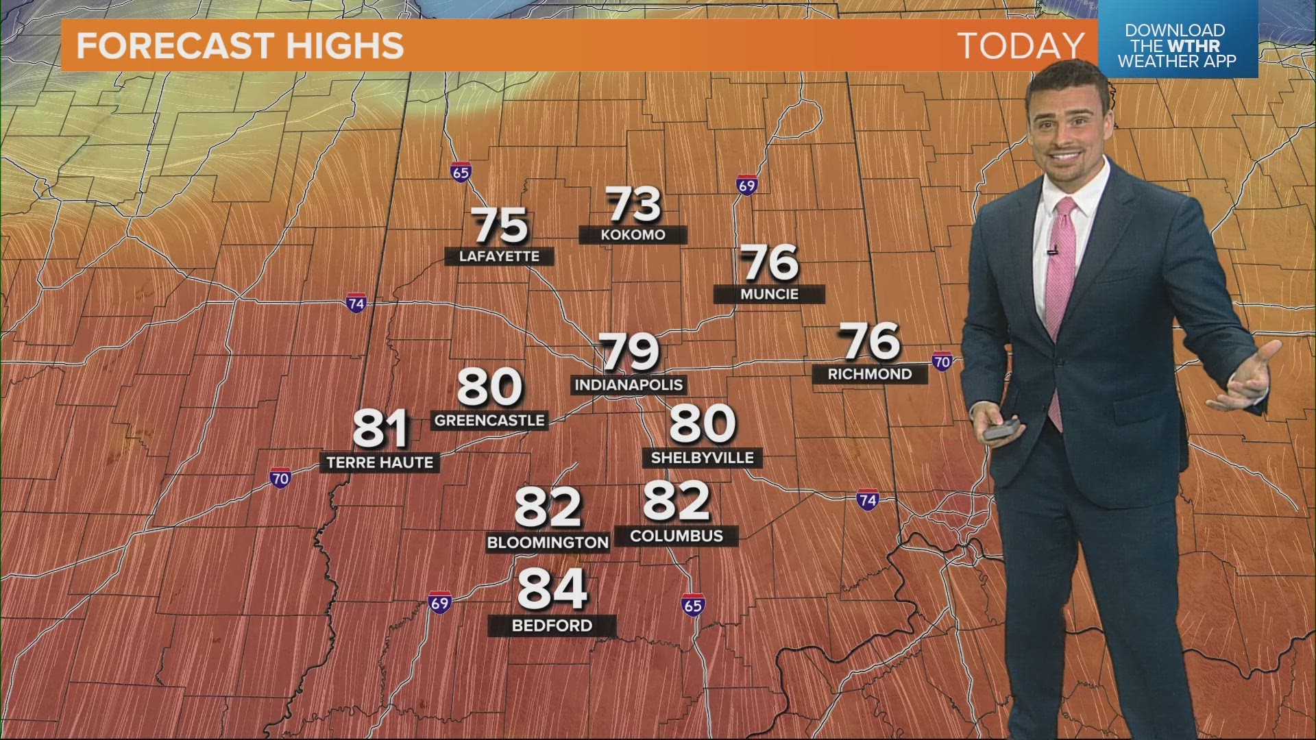
There have been some weaker fronts and scattered storms this week, after a stunning start with 80s and sunshine. A final cold front will hit Thursday evening and night, dropping highs back down to 50s. There may even be some frost this weekend. As we switch from warm to cool air, storm chances are likely.
Who will get storms Thursday evening?
Most of Indiana will get some scattered rain and most likely some rumbles of thunder. Central Indiana could get some stronger storms, while southern Indiana gets the worst.
Most of Thursday is quiet and really nice. Enjoy the sunshine as temperatures rebound to some 60s and 70s with some south winds at 5-15 mph. After 8 p.m., we will start watching some Illinois storms getting close to Indiana.
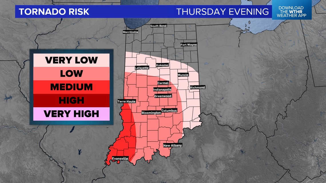
The heart of Thursday's low pressure system will track along Interstate 70. That will keep the strongest storms south of the interstate. Most of Indiana has a chance for rain, but the chance for intense thunderstorms with wind, hail and isolated tornado threats increases farther south.


When can I expect storms?
Timing may change by a couple hours. Once we see the storms and they pick up speed, we'll be able to get more accurate tracking data, and we'll be able to see where the strongest storms are and where they are heading.
Generally, expect storms between 8 p.m. and 2 a.m. Most of the stronger storms will come into Indiana near 9 p.m. or 10 p.m. and exit the state by 1 a.m.
(NOTE: The map below indicates when storms are likely to arrive. Once they hit, you get an hour of thunderstorms with scattered rain and rumbles for a few hours later.)

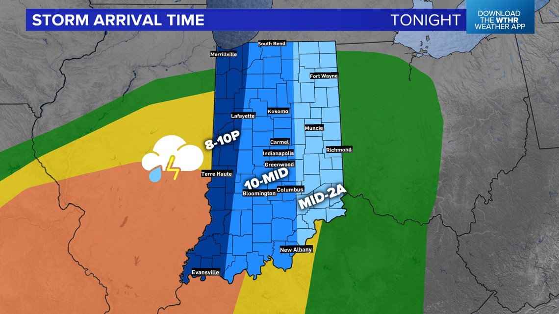
START TIMES ACROSS THE STATE
- Western Indiana: 8 p.m. - 10 p.m.
- Central Indiana: 10 p.m. - midnight
- Eastern Indiana: midnight - 2 a.m.
(Scroll down for simulated radar data.)
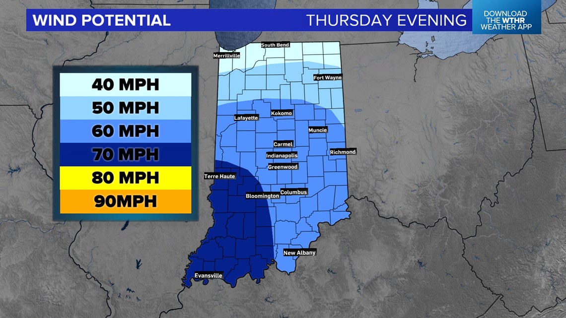
What is the chance for high winds?
When it comes to individual threats, forecasting becomes very complex. This is our best guess.
Wind is our primary threat. With more heat, these storms will likely fire up quickly across Illinois and run into one another, forming a nasty line that becomes wind-driven. The highest wind chance will be in southwestern Indiana.

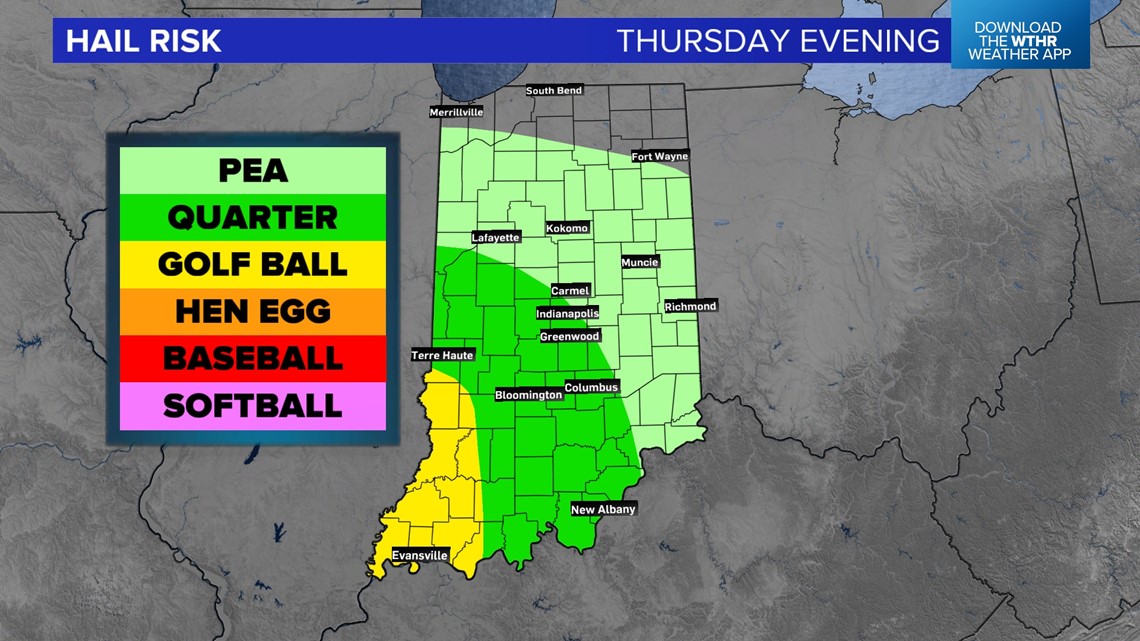
What is the chance for hail?
Generally, the wind storms will have a harder time for big hail, but 1" sized hail may fall out in some of the storms, especially if there are some breaks in the line of thunderstorms. The best chance for hail will be in central and southern Indiana.

What is the chance for a tornado?
The chance for a tornado will be low, but not zero. However, along the leading edge, wind surges start to fold on themselves and create a rotating tornado risk. The highest risk will be in Illinois, but the threat may carry over into southern Indiana.

How bad will the storms be?
Storms are likely to be pretty intense in Illinois. Once we lose some daytime heating, they should start to weaken in some areas and become nasty wind storms in others. We are not exactly sure where individual wind storms will set up, but the zone for storms seems to be marching through the majority of central and southern Indiana.

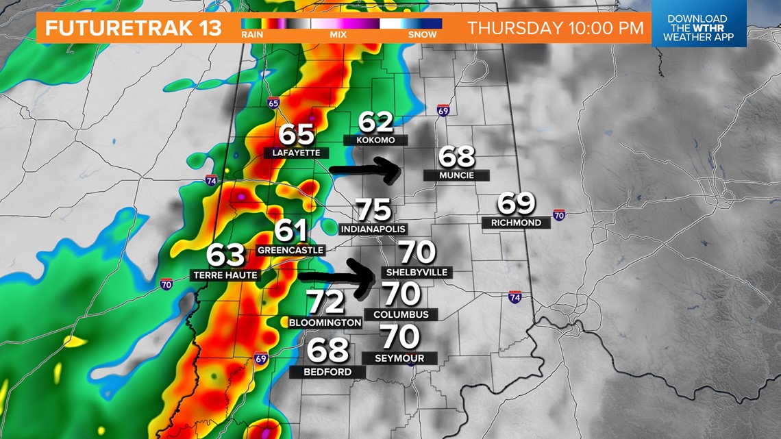
Once storms become wind-driven, they will march east and southeast. Some cells inside the line will be able to produce 60+ mph winds. In between, expect 40-50 mph winds.

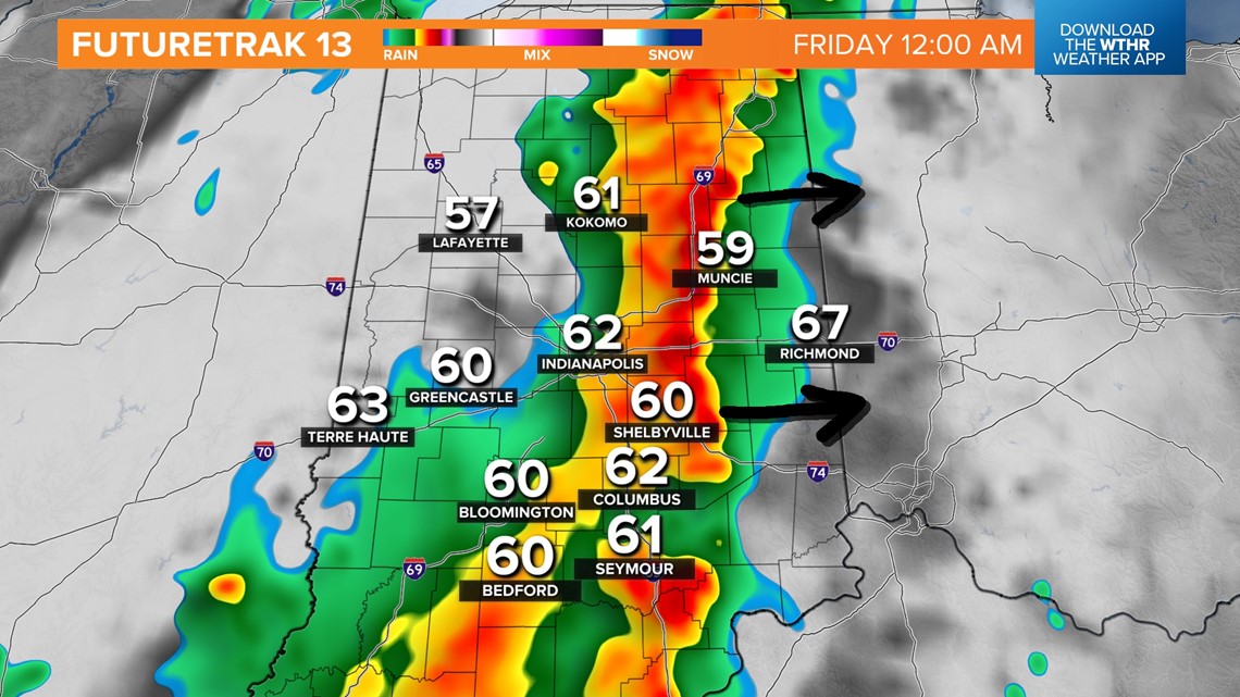
As temperatures cool, expect storms to generally weaken on the north end. The strongest storms are likely to be southern Indiana.
Few final notes...
- Expect some changes to timing, nothing drastic but an hour or two difference is possible. Overall, expect evening and early night storms. Most of Indiana should be done with widespread rain and storms by 2 a.m.
- The strongest storms need heat and moisture. A weak front blew across the state on Wednesday. Thunderstorms will need the air to rejuvenate before they arrive Thursday evening. It's possible. If we struggle, that will keep storms likely farther south, with more scattered rain and rumbles across Indiana.
- At any time, a part of a storm can start doing its own thing and become intense. Stay weather aware after dinnertime Thursday.
-13News Meteorologist Matt Standridge