
INDIANAPOLIS — A line of strong storms moved through central Indiana Thursday evening, with possible tornadoes causing extensive damage in parts of Delaware and Randolph counties.
Scroll down for the latest updates following the storms:
(NOTE: This story has been updated to reflect that emergency management officials in Randolph County said early Friday that no deaths had been reported in the county, after an earlier report from police indicated that three people had died.)
Severe weather updates
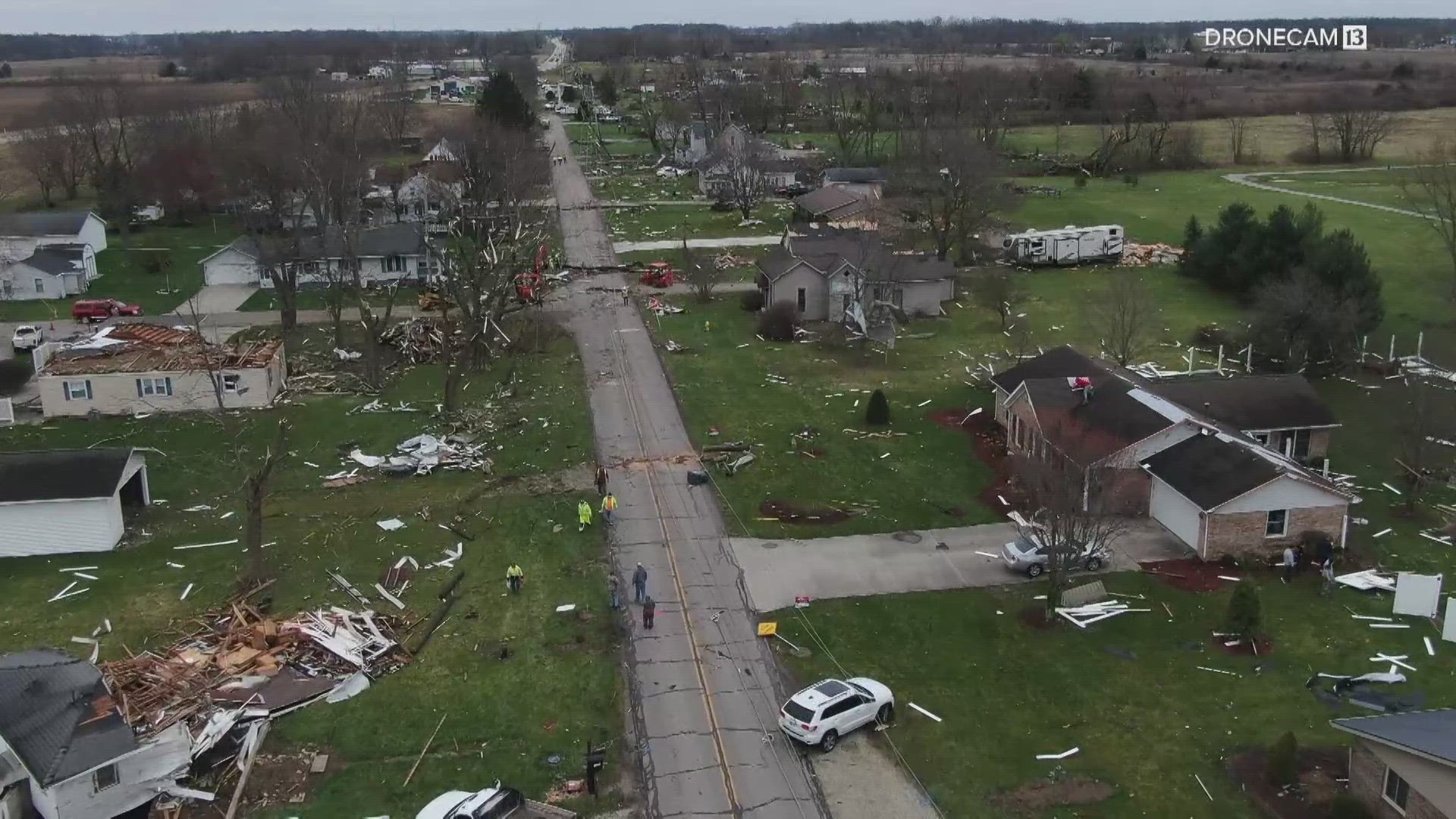
7:30 p.m. - The National Weather Service released preliminary information about the tornado that hit Selma and Winchester Thursday night. The service said the tornado started in Selma at 7:37 p.m., traveling east for 25 miles before ending near Union City on the Indiana-Ohio border.
Wind speeds in the tornado reached an estimated 155-165 mph.
3:25 p.m. - The National Weather Service confirmed on Friday, the tornado that hit Winchester had a preliminary EF3 rating based on the damage. An EF3 tornado has winds of 136-165 mph.
3:15 p.m. - Crisis counseling is available for those who were impacted by the storm. The Disaster Distress Helpline is open at 1-800-985-5990.
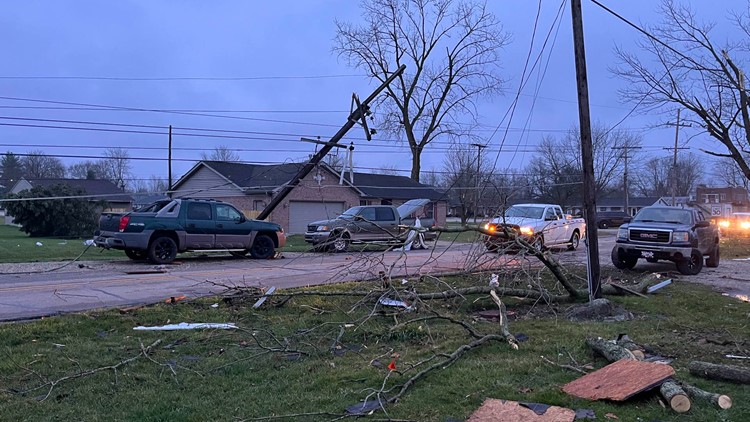
11:37 a.m. - Indiana Michigan Power said crews have discovered more than 100 more broken poles in Randolph and Delaware counties. In Selma, 850 customers are still without power. In the Winchester area, about 3,600 customers have no power.
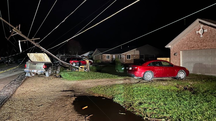
11 a.m. - 13News has crews in both Delaware and Randolph counties as there were reports of tornadoes that caused widespread damage and injuries Thursday night.
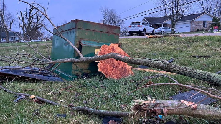
PHOTOS: 13News' coverage of Randolph County storm damage


PHOTOS: 13News' coverage of Delaware County storm damage


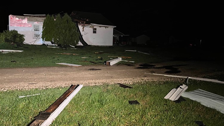


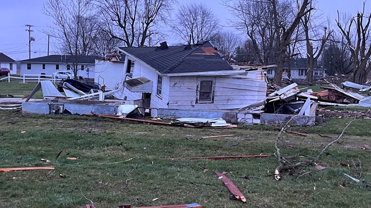


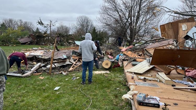
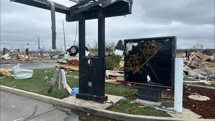
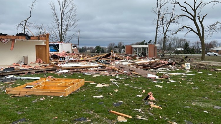
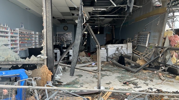
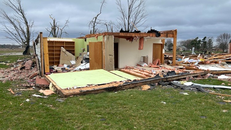
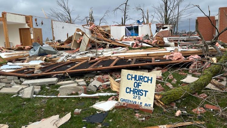
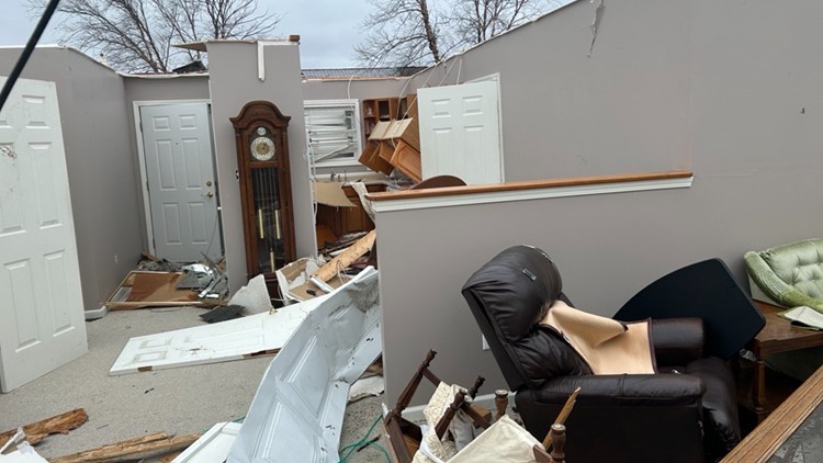
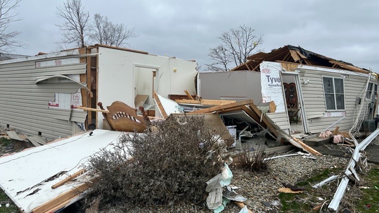
9:35 a.m. - Winchester Mayor Bob McCoy said in a press conference Friday morning that three of those injured are believed to be in critical condition. Twenty-two homes were possibly destroyed, and more than 100 were badly damaged. Some businesses, like a Taco Bell, were completely leveled.
Indiana Gov. Eric Holcomb said state agencies such as INDOT, Indiana State Police and the Indiana Department of Homeland Security will "be here until the job is done" and said the state would work to streamline resources to people impacted.
8:40 a.m. - 13Sunrise has team coverage on the storms from March 14, 2024:
8 a.m. - 13Sunrise reporter Samantha Johnson shared photos from the damage in Winchester.
7:50 a.m. - The Indiana Bureau of Motor Vehicles said the Winchester Branch and Processing Center will be closed Friday, March 15 due to damage at the facility.
7:30 a.m. - The Indiana Department of Homeland Security said in a statement that the Red Cross had set up at Winchester High School, located at 700 N. Union Street. A reunification center is at Wapahani High School, located at 10401 E. County Road 167 South, for any displaced residents "or others who may have been separated from loved ones during the storms."
Selma Elementary, located at 200 East St., is serving as the evacuation point for people with damage to their homes.
4:55 a.m. - In an update early Friday, the Randolph County Homeland Security Emergency Management Agency said 38 injuries had been reported, with 12 people transported to nearby hospitals.
The agency said no deaths had been reported, and no people were reported missing as of 3:30 a.m. March 15.
At that time, 4,756 customers were without power in Randolph County in connection with the storm.
Officials will begin a thorough damage assessment after daybreak Friday, and the next media briefing is expected at 9:30 a.m.
3:50 a.m. - The National Weather Service Indianapolis office says survey teams will be assessing damage with "the primary focus area...from Selma to Winchester with additional survey teams being sent as needed."
3:45 a.m. - Indiana Task Force 1 posted video of its 2:30 a.m. departure for Winchester on social media.
Thursday – March 14
11:02 p.m. - State police are asking the public to avoid the area where damage occurred in Winchester. Those wishing to volunteer can go to the White River Volunteer Fire Department at 1023 North Old Highway 27 in Winchester.
10:32 p.m. - The Randolph County Sheriff's Department has closed SR 32 from SR 1 to U.S. 27 - a stretch of about 9 miles - due to debris and downed power lines following Thursday's storms.
10:04 p.m. - Delaware County emergency management officials reported that early indications suggest up to 50% of the structures in the town have been damaged.
One person was reportedly transported to the hospital for treatment and other minor injuries were reported.
10:01 p.m. - 13News viewer Shawn Mead shared video of a tornado near Winchester Thursday night.

9:50 p.m. - A Severe Thunderstorm Warning has been issued for Shelby County until 10:15 p.m. and for Decatur, Rush and Shelby counties until 10:30 p.m.
9:40 p.m. - A Severe Thunderstorm Warning has been issued for Brown, Johnson and Morgan counties until 10 p.m.
9:35 p.m. - Indiana State Police confirmed to NBC News three people died in a mobile home park on North Cash Drive in Winchester, but the Indiana Department of Homeland Security said shortly before midnight that those deaths were not confirmed. IDHS said state and local officials were still working to confirm the earlier reports.
Indiana State Police Supt. Doug Carter said the initial report of three fatalities came from someone at ISP, but that the report wasn't "nefarious" in nature.
9:30 p.m. - A Severe Thunderstorm Warning has been issued for Johnson and Shelby counties until 10:15 p.m.
9:26 p.m. - Meteorologist Sean Ash says the storm axis is moving southeast of Indianapolis through the rest of the night as storms continue to move through central Indiana.
9:20 p.m. - A Severe Thunderstorm Warning has been issued for Owen County until 10:15 p.m.
9:17 p.m. - A Severe Thunderstorm Warning has been issued for Monroe and Morgan counties until 9:45 p.m.
9:16 p.m. - A Severe Thunderstorm Warning was issued for Wayne County until 10 p.m. Thursday.
9:07 p.m. - A Severe Thunderstorm Warning is in effect until 9:15 p.m. for Johnson and Marion counties. A second warning is in effect until 9:30 p.m. for part of Marion County.
8:58 p.m. - A Tornado Warning has been issued for Monroe and Owen counties until 9:30 p.m. A storm capable of producing a tornado is approaching Gosport.
8:54 p.m. - A Severe Thunderstorm Warning has been issued for Monroe, Morgan, Owen and Putnam counties until 9:45 p.m.
8:52 p.m. - Video shared with 13News by viewer Trinity Moore shows an apparent tornado near Selma Thursday night.

8:47 p.m. - The Delaware County EMA is asking residents of the county who sustained damage in Thursday's storms fill out a property damage form.
8:45 p.m. - A Tornado Warning has been issued for Wayne County until 9:15 p.m. A severe storm capable of producing a tornado was located near New Castle at 8:42 p.m. Golf ball-sized hail is also possible with the storm, which included radar-indicated rotation.
8:42 p.m. - The Delaware County Sheriff's Office reports storm damage due to a possible tornado and major hail in Selma. State Road 32 has been closed between CR 500 East and CR 750 East through Selma due to the damage.
8:40 p.m. - A Severe Thunderstorm Warning has been issued until 9:15 p.m. for counties including Johnson, Marion, Morgan and Wayne.
8:30 p.m. - A Tornado Warning has been issued for Henry County until 9 p.m. The National Weather Service reports a severe thunderstorm capable of producing a tornado is located near New Castle, moving east toward Mooreland and Mount Summit.
8:22 p.m. - A Severe Thunderstorm Warning has been issued for Boone, Hamilton, Hancock, Madison and Marion counties until 8:45 p.m. Thursday.
8:18 p.m. - A Severe Thunderstorm Warning was issued for Montgomery, Owen and Putnam counties until 8:45 p.m.
8:10 p.m. - A Severe Thunderstorm Warning has been issued for Henry and Madison counties until 8:45 p.m.
8:01 p.m. - A Severe Thunderstorm Warning has been issued for Hamilton and Madison counties until 8:45 p.m.
7:51 p.m. - A Severe Thunderstorm Warning has been issued until 8:30 p.m. for Boone, Hamilton, Montgomery and Putnam counties.
7:47 p.m. - A Severe Thunderstorm Warning is in effect until 8:15 p.m. for Hamilton, Hancock and Madison counties.
7:45 p.m. - The Tornado Warning for Delaware County now includes Randolph County until 8:30 p.m.
7:35 p.m. - A Severe Thunderstorm Warning is in effect for Hamilton County until 7:45 p.m. and for Boone and Montgomery counties until 8 p.m.
7:30 p.m. - Severe Thunderstorm Warnings are in effect for Blackford, Hamilton, Madison and Tipton counties until 8 p.m.
7:22 p.m. - A Tornado Warning has been issued for Delaware County until 7:45 p.m.
7:05 p.m. - A Severe Thunderstorm Warning was issued for Delaware and Madison counties until 7:45 p.m.
7 p.m. - A Severe Thunderstorm Warning was issued for Grant County until 7:15 p.m. and for Boone, Clinton, Hamilton, Montgomery and Tipton counties until 7:30 p.m.
6:33 p.m. - A Severe Thunderstorm Warning was issued for Miami County until 7 p.m.
6:25 p.m. - A Severe Thunderstorm Warning for Blackford and Grant counties is in effect until 7 p.m.
6:24 p.m. - A Severe Thunderstorm Warning for Clinton, Howard and Tipton counties is in effect until 7 p.m.
6:11 p.m. - A Severe Thunderstorm Warning for Clinton County is in effect until 6:45 p.m.
6:09 p.m. - A Severe Thunderstorm Warning for Howard and Tipton counties is in effect until 6:45 p.m.
6:05 p.m. - Duke Energy is reporting 3,614 power outages.
6:02 p.m. - A Severe Thunderstorm Warning for Boone, Clinton and Tippecanoe counties is in effect until 6:45 p.m.
5:58 p.m. - A Severe Thunderstorm Warning for Grant County is in effect until 6:30 p.m.
5:56 p.m. - A Severe Thunderstorm Warning for Boone, Clinton, Montgomery and Tippecanoe counties is in effect until 6:45 p.m.
5:51 p.m. - A Tornado Warning for Grant, Huntington and Wells counties is in effect until 6:15 p.m.
5:49 p.m. - A Severe Thunderstorm Warning for Cass, Grant and Miami counties is in effect until 6:15 p.m.
5:37 p.m. - A Tornado Warning for southeastern Wabash County and northwestern Grant County is in effect until 6 p.m.
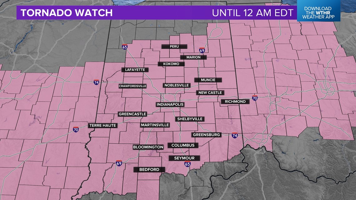
5:20 p.m. - A Tornado Watch was issued until midnight for Bartholomew, Blackford, Boone, Brown, Carroll, Cass, Clinton, Decatur, Delaware, Fayette, Fountain, Grant, Hamilton, Hancock, Hendricks, Henry, Howard, Johnson, Lawrence, Madison, Marion, Miami, Monroe, Montgomery, Morgan, Owen, Putnam, Randolph, Rush, Shelby, Tippecanoe, Tipton, Warren, Wayne and White counties.

12:43 p.m. - A Severe Thunderstorm Watch is in effect until 4 p.m. for the following counties: Bartholomew, Blackford, Brown, Decatur, Delaware, Fayette, Grant, Hancock, Henry, Johnson, Lawrence, Madison, Randolph, Rush, Shelby and Wayne.
12:16 p.m. - These counties remain under a Severe Thunderstorm Watch until 4 p.m.: Bartholomew, Blackford, Boone, Brown, Clinton, Decatur, Delaware, Fayette, Grant, Hamilton, Hancock, Hendricks, Henry, Howard, Johnson, Lawrence, Madison, Marion, Monroe, Morgan, Owen, Randolph, Rush, Shelby, Tipton and Wayne.
12:14 p.m. - Morgan and Hendricks counties have been dropped from the Severe Thunderstorm Warning which is in effect until 12:30 p.m.
12:08 p.m. - A Severe Thunderstorm Warning is in effect for Hamilton, Hancock, Hendricks, Marion, Morgan and Shelby counties until 12:30 p.m.
12:03 p.m. - A Severe Thunderstorm Watch is in effect for the following counties until 4 p.m.: Bartholomew, Blackford, Boone, Brown, Cass, Clinton, Decatur, Delaware, Fayette, Grant, Hamilton, Hancock, Hendricks, Henry, Howard, Johnson, Lawrence, Madison, Marion, Miami, Monroe, Morgan, Owen, Randolph, Rush, Shelby, Tipton, Wayne and White.
11:54 a.m. - A Severe Thunderstorm Warning has been issued for Howard and Tipton counties until 12:15 p.m.
11:50 a.m. - A Severe Thunderstorm Warning is now effect for Boone, Hamilton, Hendricks and Marion counties until 12:15 p.m.
11:07 a.m. – A Severe Thunderstorm Warning for Boone, Carroll, Clinton, Fountain, Hendricks, Montgomery, Putnam, Tippecanoe and Warren counties is in effect until 11:30 a.m. this morning.
10:54 a.m. – A Severe Thunderstorm Watch was issued for central Indiana until 4 p.m.