

FLORIDA, USA — Satellite images from the National Oceanic and Atmospheric Administration show the power of two strong hurricanes brewing along the Gulf of Mexico and eastern parts of the United States.
Idalia strengthened into a hurricane on Tuesday and is expected to intensify by the time it comes ashore as a Category 3 hurricane on Wednesday morning.
The storm was classified as a Category 2 hurricane late Tuesday afternoon.
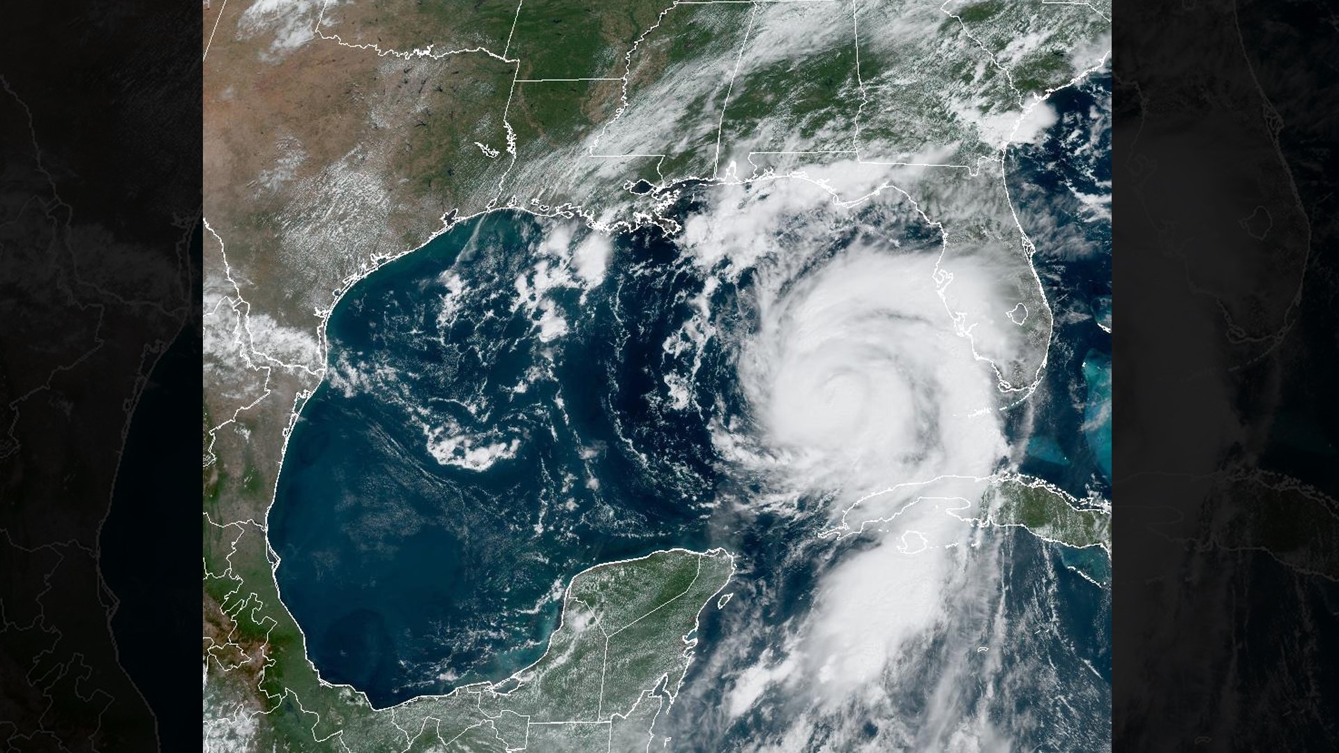
The satellite images above were taken from NOAA's 11 a.m. update on Tuesday.
Officials warned a deadly storm surge of up to 15 feet of water is possible for the Big Bend area, which is the part of Florida where the panhandle bends in the peninsula.
It could be a big blow to a state still working to rebuild from damage suffered during Hurricane Ian last year.
The National Weather Service in Tallahassee called Idalia “an unprecedented event” since no major hurricanes on record have ever passed through the bay bordering the Big Bend region.
"Looking back through recorded history, NO major hurricanes have ever moved through the Apalachee Bay. When you try to compare this storm to others, DON'T. No one has seen this," the NWS in Tallahassee warned on social media.
The National Hurricane Center also warned the combination of a dangerous storm surge and the tide will cause normally dry areas to be flooded by rising waters moving inland from the shoreline.
The water could reach the following heights above ground in these places, according to the latest reports from The National Hurricane Center at 2 p.m.:
Aucilla River, FL to Yankeetown, FL - 10-15 ft.
Yankeetown to Chassahowitzka, FL - 7-11 ft.
Chassahowitzka, FL to Anclote River, FL - 6-9 ft.
Ochlockonee River, FL to Aucilla River, FL - 7-11 ft.
Anclote River, FL to Middle of Longboat Key, FL - 4-7 ft.
Tampa Bay - 4-7 ft.
Carrabelle, FL to Ochlockonee River, FL - 4-7 ft.
Middle of Longboat Key, FL to Englewood, FL - 3-5 ft.
Englewood, FL to Chokoloskee, FL - 2-4 ft.
Charlotte Harbor - 2-4 ft.
Indian Pass, FL to Carrabelle, FL - 3-5 ft.
Mouth of the St. Mary's River to South Santee, SC - 2-4 ft.
South Santee, SC to Surf City, NC - 1-3 ft.
Chokoloskee, FL to East Cape Sable, FL - 1-3 ft.
Flagler/Volusia County Line, FL to Mouth of St. Mary's River - 1-3 ft.
Indian Pass to Mexico Beach -1 to 3 ft.
Florida Keys - 1-2 ft.
The deepest water is projected to occur along the immediate coast in areas of onshore winds, where the surge will be accompanied by large and dangerous waves.
Surge-related flooding depends on the relative timing of the surge and the tidal cycle, and can vary greatly over short distances.
As of 2 p.m. Tuesday afternoon, the center of Hurricane Idalia was moving toward the north near 14 mph toward the Floridian Gulf Coast, according to reports from the National Hurricane Center.
A few tornadoes will be possible along the west central Florida coast through Tuesday night The tornado threat will also spread northward into the Florida Big Bend throughout tonight, and toward southeast Georgia and the coastal Carolinas by Wednesday, according to the National Hurricane Center's update on 2 p.m. Tuesday.
A faster motion toward the north and north-northeast is expected through early Wednesday while Idalia approaches the Gulf coast of Florida.
A turn toward the northeast and east-northeast is forecast for late Wednesday and Thursday, bringing the center of Idalia near or along the coasts of Georgia and the Carolinas.
Hurricane-force winds extend outward up to 15 miles from the center and tropical-storm-force winds extend outward up to 160 miles.
President Joe Biden signed an emergency declaration for the state on Monday.
As Floridians living on the state's western coast prepare for Idalia, tropical storm conditions from Hurricane Franklin are expected in Bermuda beginning as early as Wednesday morning.
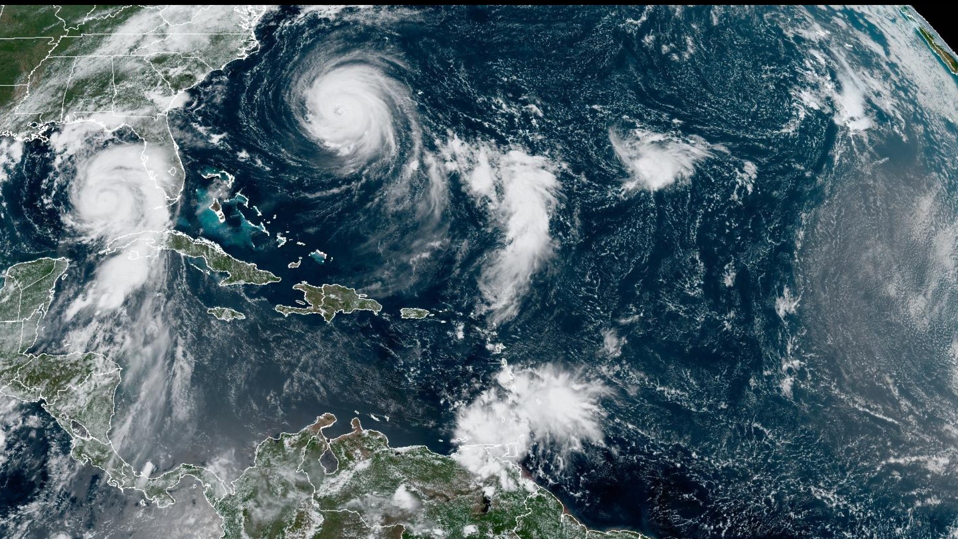
A Tropical Storm Warning has already been issued for that area. The center of Hurricane Franklin is expected to pass to the northwest of Bermuda on Wednesday.
Life-threatening surf and rip currents are already happening along the east coast, and are expected to continue throughout the next several days.
Maximum sustained winds are near 130 mph with higher gusts. Franklin is currently a Category 4 hurricane on the Saffir-Simpson Hurricane Wind Scale.
Steady weakening is forecast during the next several days, but Franklin will remain a hurricane through late this week.