Thus far the forecast is playing-out as expected. We'll be in snow globe conditions for the remainder of the afternoon with a period of moderate to heavy snow rates between now and 5 PM.
Temperatures continue to hover between 30°-32° and we're expecting road conditions to range from wet to slushy within heavier bursts of snow. Expect a slower drive home from work/school within the Winter Weather Advisory area.
Our snowfall forecast hasn't change much at all. Still expecting between 1" - 3" around Indy... with the higher side more likely achieved north of downtown Indy. An inch or less for areas south of I-70 with 3" to locally 5" along/north of a line from Lafayette-Tipton-Hartford City-Portland.
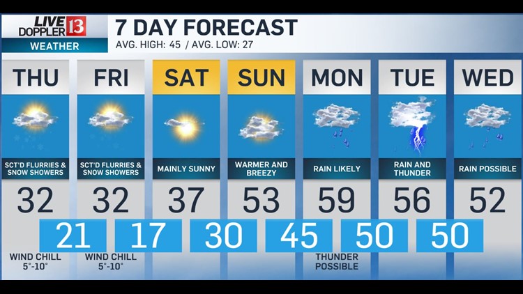
Snow ends west-to-east between 5 PM - 8 PM with road conditions likely worsening after sunset as temperatures drop into the lower 20s by Thursday morning.
This means additional school delays/cancellations are possible, if not likely, around central/northern Indiana on Thursday. Noticeably colder wind chills in the 5°-10° Thursday morning definitely grabs your attention out the door.
There will be little recover in high temperatures that struggle to hit freezing in the afternoon. Scattered flurries and snow showers develop and some linger into Friday afternoon.
The weekend begins on a brighter note with sunshine Saturday. Latest guidance suggests a rather significant warm-up Sunday with temperatures surging into the 50s on a gusty southwest wind that marks the beginning of a 3-4 day stretch of spring-like warmth.
Highs near 60° early next week with rain likely and thunderstorms possible.